
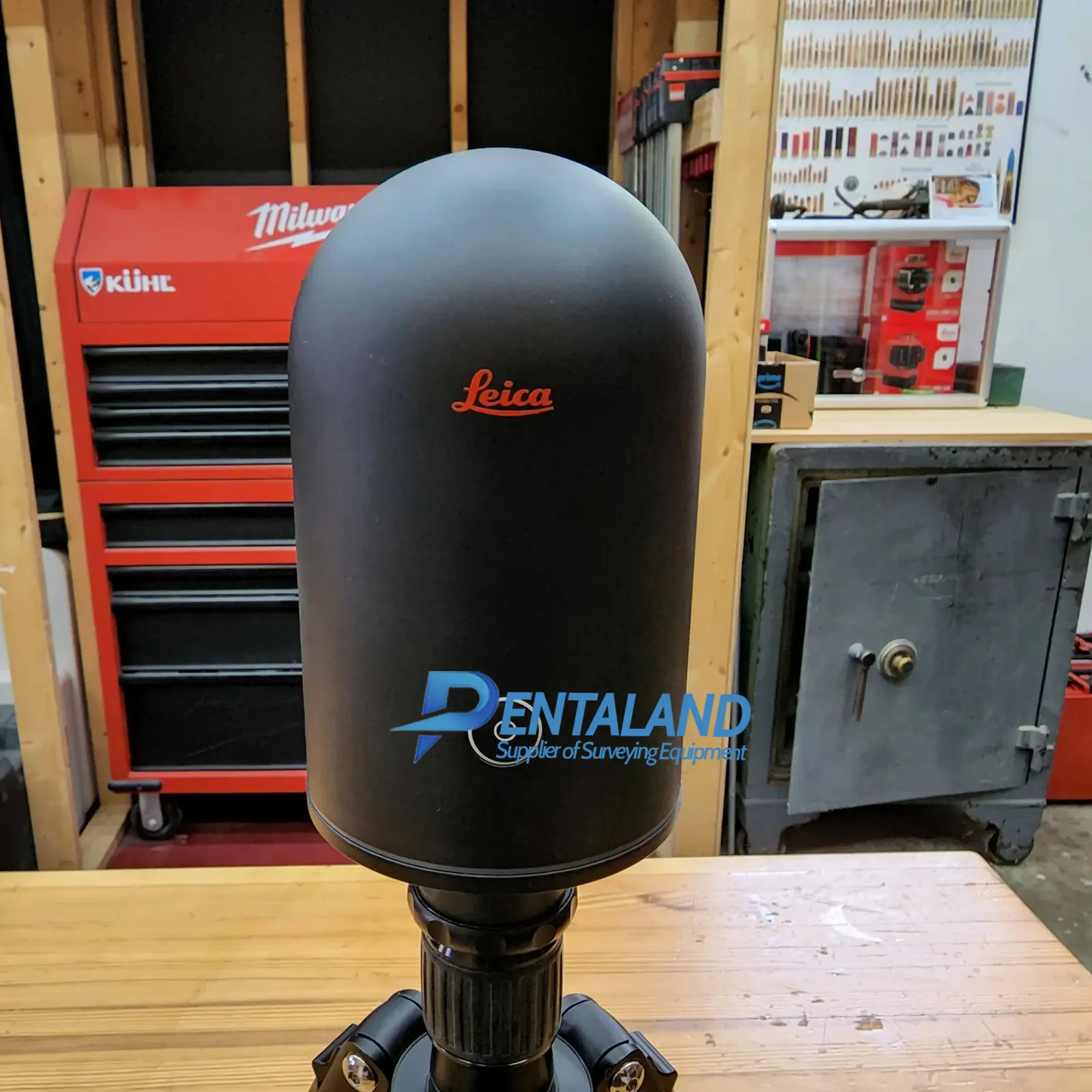


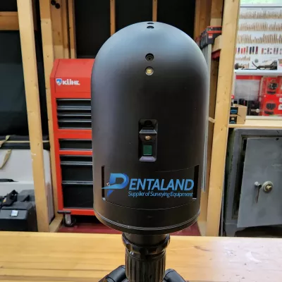

Used Leica BLK360 G1 Laser Scanner
$6,000
Related Products
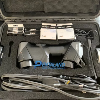
Used Leica BLK360 Laser Scanner for sale, bundle with Leica BLK360 & Cyclone Register 360 (BLK Edition), plus the Cyclone Field 360 App. Still like new, fully inspected, serviced and calibrated by Leica authorized, everything is in excellent perfect condition.
Leica BLK360 & Cyclone Register 360 (BLK Edition), plus the Cyclone Field 360 App is included with this Leica BLK360 purchase. Leica Cyclone REGISTER 360 (BLK Edition) is a simplified version of Leica Cyclone REGISTER. It features an intuitive UI, guided workflows and an easy process for sharing data downstream with more advanced tools like JetStream and TruView. Alternatively, export your cloud as a standard E57 file or Autodesk’s native RCP file format.
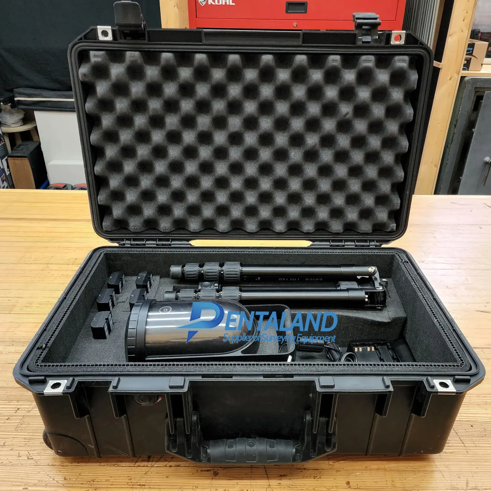
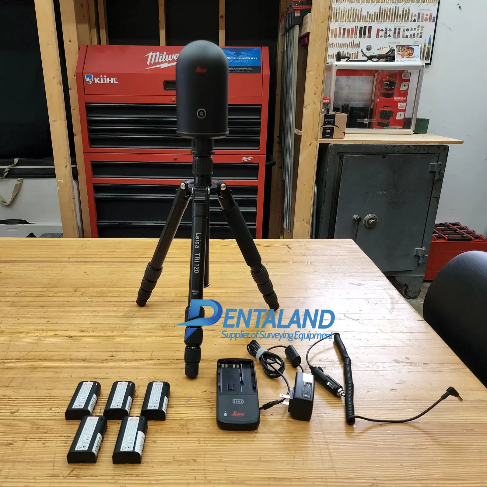
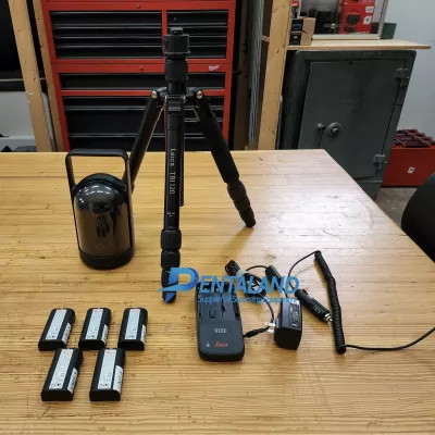
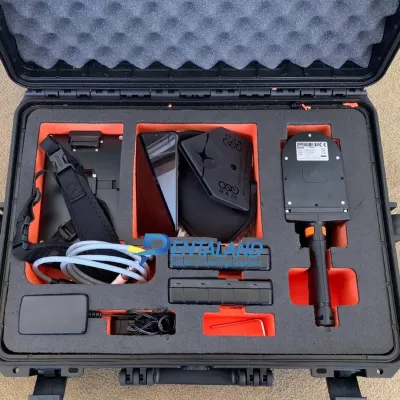
Package includes:
- Leica BLK360 Laser Scanner
- Leica BLK360 & Cyclone Register 360 (BLK Edition), plus the Cyclone Field 360 App
- 5x GEB212 Lithium-Ion Battery
- GKL312 Battery Charger
- Car-Adapter for GKL
- Leica BLK360 Tripod Adapter
- Leica TRI 120 - Very Compact and Stable Tripod
- Pelican 1150 Case
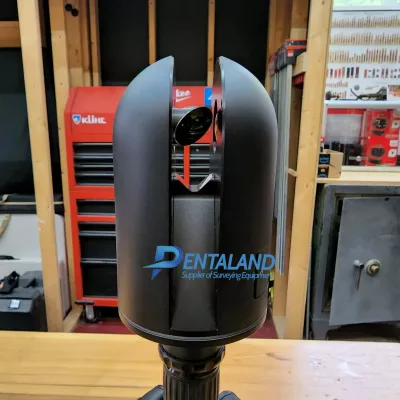
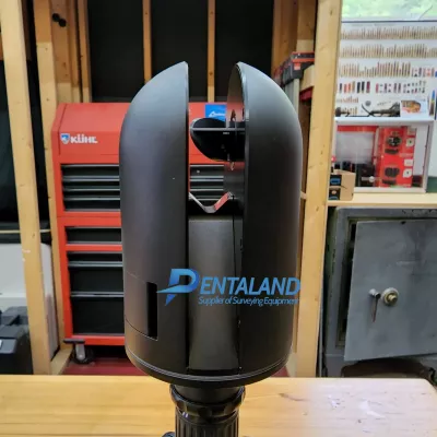
Leica BLK360 Laser Scanner | An imaging laser scanner for both beginners and professionals.
The award-winning Leica BLK360 G1 is the original Leica BLK laser scanner, packed with features that make it reliable, precise, and easy to use. A scanner that’s perfect for those new to reality capture, it could be the right piece of kit for your laser scanning workflow
BLK360 has been honored with multiple industry and industrial design awards.

The Leica BLK360 is designed to help new-to-LiDAR users capture point clouds and unlock the potential of using them in many different applications. Ranging from practical uses, such as architecture and surveying, to creative possibilities, such as VR workflows and media location scouting, the BLK360 is meant to make reality capture accessible to everyone.
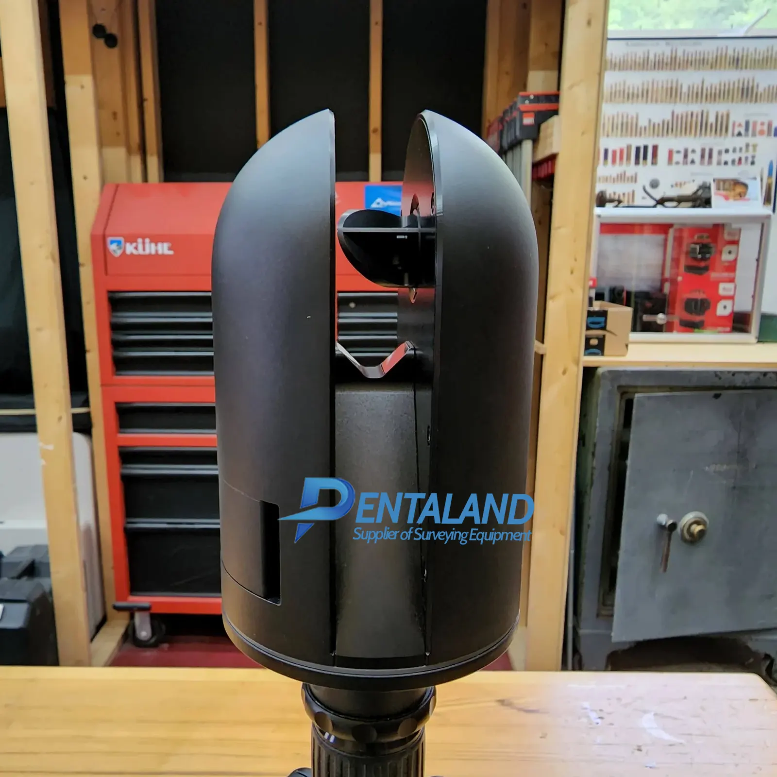
The BLK360 captures 360,000 points per second, panoramic HDR imagery, and has thermal imaging capability. It is fully compatible with the Leica Geosystems Cyclone suite of Reality Capture software and powerful enough to be a useful addition to an experienced surveyor’s toolkit.
FEATURES
BLK360 & Cyclone Register 360 (BLK Edition), plus the Cyclone Field 360 App
Get the bundle that makes capturing reality as easy as clicking a button
BLK360 Imaging Laser Scanner
- smallest and lightest laser scanning system in the world
- Weight: 2.2 lbs, Size: 6.5” tall x 4” in diameter
- Less than 3 minutes for a full 360° reality capture
- Speed of capture 360,000 points per second
- Range 60m radius
- 3-D image point cloud available in real time
- Selectable resolution settings
- Calibrated full spherical image, HDR, LED flash support
- Control all aspects of the reality capture process remotely on Cyclone Field 360 app for Apple or Android
- Automatically register and visualize scan data in the field
- Mark up, tag, and collaborate on scans while on the job site
- Reduce rework requests and share reality data remotely
- IP54 Liquid & Dust Protection
The BLK360 represents the confluence of art and engineering. Fast image and point cloud processing; Lightweight, portable and easy to carry around; Easy to use one-button scanning; Enhanced connectivity and collaboration capabilities with cloud sync; and Two-in-one 360º image documentation and laser scan data.
For a detailed product overview, please visit the Leica BLK360 product page.
Specifications:
| GENERAL | |
| Imaging scanner | 3D scanner with integrated spherical imaging system and thermography panorama sensor system |
|
DESIGN & PHYSICAL |
|
| Housing | Black anodized aluminium |
| Dimensions (H x D) | 165 x 100 mm |
| Weight | 1 kg |
| Transport cover | Hood with integrated floorstand |
| Mounting mechanism | Button-press quick release |
|
OPERATION |
|
|
Standalone operation |
One-button operatio |
|
Remote operation |
iPad app, Apple iPad Pro® 12.9”/iOS 10 or later |
| Wireless communication | Integrated wireless LAN (802.11 b/g/n) |
| Internal memory | Storage for > 100 setups |
| Instrument orientation | Upright and upside down |
|
POWER |
|
| Battery type | Internal, rechargeable Li-Ion battery (Leica GEB212) |
| Capacity | Typically >40 setups |
|
SCANNING |
|
| Distance measurement system | High speed time of flight enhanced by Waveform Digitizing (WFD) technology |
| Laser class | 1 (in accordance with IEC 60825-1:2014) |
| Wavelength | 830 nm |
| Field-of-view | 360° (horizontal) / 300° (vertical) |
| Range | min. 0.6 - up to 60 m |
| Point measurement rate | up to 360’000 pts / sec |
| Ranging accuracy | 4mm @ 10m / 7mm @ 20m |
| Measurement modes | 3 user selectable resolution settings |
| IMAGING | |
| Camera system | 15 Mpixel 3-camera system, 150Mpx full dome capture, HDR, LED flash Calibrated spherical image, 360° x 300° |
| Thermal Camera | FLIR technology based longwave infrared camera Thermal panoramic image, 360° x 70° |
| Image modes |
|
| PERFORMANCE | |
| Measurement speed | < 3 min for complete fulldome scan, spherical image & thermal image |
| 3D point accuracy | 6mm @ 10m |
| ENVIRONMENTAL | |
| Robustness | Designed for indoor and outdoor use |
| Operating temperature | +5 to +40° C |
| Dust/Humidity | Solid particle/liquid ingress protection IP54 (IEC 60529) |
|
DATA ACQUISITION |
|
| Live image and scanned data streaming | |
| Live data viewing and editing | |
| Automatic tilt measurements | |
Documentations
Pentaland
Pentaland Surveying specialized in sale and service of surveying instrument and measuring equipment with more than 15 year experience. We supply a wide range of latest instruments, accessories and consumables for measuring, surveying applications and construction such as 3D Laser Scanner, Digital Templating System, GPS GNSS Systems, Ground Penetrating Radar, Laser Tracker, Phased Array Flaw Detector, Pre-Owned 3D Scanners, Robotic Total Stations, Thermal Imaging Camera, XRF Analyzers.
Categories
Manufacturer
© 2014 - 2026 Pentaland | All Rights Reserved
